Late Tuesday, the team was able to begin its first work with the Moving Vessel Profiler (MVP). Since then, this key tool has gathered a pile of data that has provided the scientists food for serious thought as they work to decipher the confusing paths lower-oxygen water is following. The work to date confirms that nothing’s ever simple.
The MVP (see video below) is a system towed behind the ship that moves up and down as directed. It rapidly collects data about water properties such as temperature and oxygen levels as the ship steams along a prescribed path. While the team gets more detailed information from a CTD cast, the MVP allows them to survey a large area of many times more quickly.
The MVP system includes a main instrument along with two heavy metal “fish” towed on the same cable that weight the system down so it can stay at desired depths. The fish also include additional instrumentation. Unfortunately, the one with a rapid oxygen sensor wasn’t working properly, so they had to work with a spare that doesn’t measure oxygen. But, while they are fixing that problem, there’s still much they can learn.
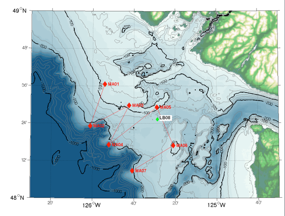
The team began towing the MVP at the western flank of an area called La Perouse Bank (see MA01 on map to right), then out to the edge of the continental shelf, and then back in and out from there in a zig-zag pattern.
Choosing that path began with a tip from colleague Bill Crawford who suggested the site on the continental shelf where the team would likely find the lowest oxygen levels (LB08 on map) due to not only upwelling, but also additional bacterial activity on the shelf further drawing down oxygen. With an earlier CTD case they confirmed that was the case, so they knew that this had to be a point on the paths lower-oxygen water takes after it upwells offshore. The zig-zag pattern was built around LB08 with the goal of mapping that path.
Already the team has been able to collect nearly 200 profiles of specific swaths of water that they’re working to interpret. Without oxygen data for now, they are relying on other indicators of upwelled water, such as lower temperatures.
So far they are not finding a simple path from the depths offshore to the LB08 site. Instead, they’ve found the presumed upwelled waters most pronounced between sites MA05 and MA06—meaning parallel to the coast of Vancouver Island. But other areas don’t have a strong upwelling signal apparent, meaning they may not yet found a main path offshore to inshore.
The team hasn’t confirmed this hypothesis yet, but they think that low-oxygen water at LB08 may, surprisingly enough, actually come there from the inshore direction. That would mean the upwelled water taking some other path inward, with some of that making its way into the Juan de Fuca Strait, but at least a portion finding another path north, parallel to shore and then back outward past LB08.
Work is already underway to explore this idea. The larger, more defined path inland may be the Juan de Fuca canyon. The side path north may be what’s called Tully Canyon, named in honor of John P. Tully, a pioneering Canadian oceanographer who first identified a dome of upwelled water in the region in the 1950s. As Richard Dewey says, “We’re far from figuring this out just yet.”